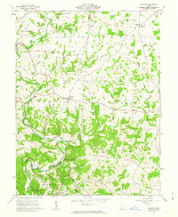
1961 Map of Decatur
USGS Topo · Published 1963About this map
Decatur serves as a central hub in this early 1960s survey of southern Ohio, where the rolling landscape is defined by the winding waters of Eagle Creek and its many tributaries. The area sits within the historic Virginia Military District, characterized by an irregular network of rural roads such as Russellville Road and Bethlehem Road that follow the natural contours of the hills. Local history is deeply rooted in the scattered religious and educational landmarks, including Bethlehem Ch, Liberty Chapel, and several buildings marked as Township Sch.
Find a feature on this map
54 named features on this map. Tap any name to fly to it.
Don’t see what you’re looking for? This feature index may not catch every label — zoom into the map to look around manually.
Map Details
Editions of this 1961 Decatur Map
2 editions found
Other maps of this area

1915 · Maysville
USGS Topo · 1:62,500

1918 · Seaman
USGS Topo · 1:62,500

1919 · Maysville
USGS Topo · 1:62,500

1928 · Higginsport
USGS Topo · 1:48,000

1929 · Springdale
USGS Topo · 1:48,000

1931 · Higginsport
USGS Topo · 1:62,500

1935 · Springdale
USGS Topo · 1:62,500

1952 · Maysville East
USGS Topo · 1:24,000

1952 · Maysville West
USGS Topo · 1:24,000
1952 · Manchester Islands
USGS Topo · 1:24,000