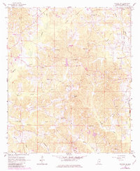
1966 Map of Decatur NW
USGS Topo · Published 1982About this map
The Choctaw Indian Reservation dominates the northwestern corner of this landscape, marking a significant cultural boundary in Newton County. This mid-century survey reveals a rural network of small communities and family landmarks, with Stratton and Sellers serving as localized hubs along the Gulf Mobile and Ohio railroad line. The terrain is defined by a dense system of waterways, including Conehatta Creek, Turkey Creek, and Dunnagin Creek, which carve through the countryside. Social and spiritual life is anchored by numerous rural congregations such as Beatline Ch and Bethlehem Ch, often accompanied by family or community burial grounds like Hollingsworth Cem. Educational infrastructure is represented by the West Decatur Sch, positioned to serve the outlying farms and timberlands before more modern consolidation.
Find a feature on this map
42 named features on this map. Tap any name to fly to it.
Don’t see what you’re looking for? This feature index may not catch every label — zoom into the map to look around manually.
Map Details
Editions of this 1966 Decatur NW Map
2 editions found
Other maps of this area

1921 · Forest
USGS Topo · 1:48,000

1922 · Forest
USGS Topo · 1:62,500

1950 · Forest
USGS Topo · 1:62,500

1952 · Forest
USGS Topo · 1:62,500

1953 · Meridian
USGS Topo · 1:250,000

1957 · Meridian
USGS Topo · 1:250,000

1965 · Meridian
USGS Topo · 1:250,000

1966 · Hickory
USGS Topo · 1:24,000

1966 · Newton
USGS Topo · 1:24,000

1966 · Decatur NW
USGS Topo · 1:24,000