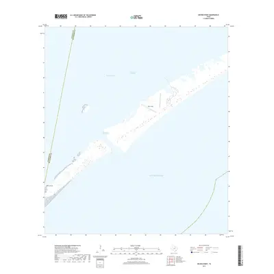
2019 Map of Decros Point
USGS Topo · Published 2019About this map
Decros Point sits at the southwestern tip of the Matagorda Peninsula, marking a critical junction between the open Gulf of Mexico and the protected waters of Matagorda Bay. The landscape is defined by the heavy engineering of the Matagorda Ship Channel, which cuts a deep passage through the barrier island to facilitate maritime traffic. This 2019 survey highlights the intersection of commerce and coastal defense, featuring Pierce Field on the peninsula. The presence of the Intracoastal Waterway running parallel to the coast further emphasizes the region's role as a vital transportation corridor for the Texas Gulf Coast. This map captures the fragile geography of the peninsula, where thin strips of land are constantly reshaped by the surrounding waters and ship traffic.
Find a feature on this map
7 named features on this map. Tap any name to fly to it.
Don’t see what you’re looking for? This feature index may not catch every label — zoom into the map to look around manually.
Map Details
Editions of this 2019 Decros Point Map
This is the sole edition of this map. No revisions or reprints were ever made.
Other maps of this area

1951 · Keller Bay
USGS Topo · 1:24,000

1952 · Palacios Point
USGS Topo · 1:24,000

1952 · Pass Cavallo SW
USGS Topo · 1:24,000

1952 · South of Palacios Point
USGS Topo · 1:24,000

1952 · Decros Point
USGS Topo · 1:24,000

1952 · Port O'Connor
USGS Topo · 1:24,000

1953 · Beeville
USGS Topo · 1:250,000

1956 · Beeville
USGS Topo · 1:250,000

1960 · Beeville
USGS Topo · 1:250,000
1980 · Carancahua Pass
USGS Topo · 1:24,000