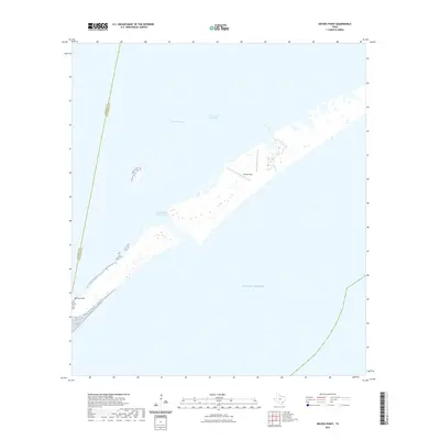
2022 Map of Decros Point
USGS Topo · Published 2022About this map
Decros Point sits at the southwestern tip of Matagorda Peninsula, serving as a critical geographic marker where the barrier island meets the sea. This coastal landscape is defined by its maritime infrastructure, most notably the Matagorda Ship Channel which cuts through the peninsula to connect the Gulf of Mexico with the sheltered waters of Matagorda Bay. The map reveals the intricate shoreline and shoals of this shifting environment, including the path of the Intracoastal Waterway running parallel to the mainland.
Find a feature on this map
7 named features on this map. Tap any name to fly to it.
Don’t see what you’re looking for? This feature index may not catch every label — zoom into the map to look around manually.
Map Details
Editions of this 2022 Decros Point Map
This is the sole edition of this map. No revisions or reprints were ever made.
Other maps of this area

1951 · Keller Bay
USGS Topo · 1:24,000

1952 · Palacios Point
USGS Topo · 1:24,000

1952 · Pass Cavallo SW
USGS Topo · 1:24,000

1952 · South of Palacios Point
USGS Topo · 1:24,000

1952 · Decros Point
USGS Topo · 1:24,000

1952 · Port O'Connor
USGS Topo · 1:24,000

1953 · Beeville
USGS Topo · 1:250,000

1956 · Beeville
USGS Topo · 1:250,000

1960 · Beeville
USGS Topo · 1:250,000
1980 · Carancahua Pass
USGS Topo · 1:24,000