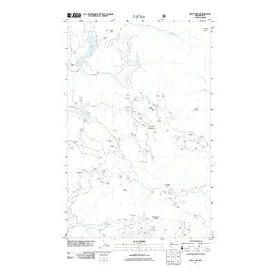
2011 Map of Deep Lake
USGS Topo · Published 2011About this map
Deep Lake sits in the northern reaches of this Stevens County landscape, surrounded by a legacy of resource extraction evident in the numerous sites scattered across the terrain. Prospectors and geologists can trace a history of mineral interests through the Thompson Iron Mine, Bechtol Mine, and Tyee Mine near the lake, extending southeast to the Jim Creek Mine and Utacan Mine. The map reveals a network of high-elevation camps and clearings that characterize the regional land use, including Speller Camp and Smackout Camp. This terrain is defined by its dramatic elevation changes, rising from Smackout Valley and Paradise Valley toward prominent peaks such as Sherlock Peak, Baldy Mountain, and Huckleberry Mountain. A complex system of drainages, including the North Fork Deep Creek, Republican Creek, and several forks of Currant Creek, carves through the mountains, dictating the placement of forest roads like Republican Creek Rd and Smackout Creek Rd.
Find a feature on this map
38 named features on this map. Tap any name to fly to it.
Don’t see what you’re looking for? This feature index may not catch every label — zoom into the map to look around manually.
Map Details
Editions of this 2011 Deep Lake Map
This is the sole edition of this map. No revisions or reprints were ever made.
Other maps of this area

1929 · Colville
USGS Topo · 1:125,000

1933 · Colville
USGS Topo · 1:125,000

1934 · Metaline
USGS Topo · 1:125,000

1942 · Metaline
USGS Topo · 1:125,000

1952 · Spirit
USGS Topo · 1:24,000

1952 · Deep Lake
USGS Topo · 1:24,000

1952 · Leadpoint
USGS Topo · 1:24,000

1952 · Boundary
USGS Topo · 1:24,000

1952 · Aladdin
USGS Topo · 1:24,000

1958 · Sandpoint
USGS Topo · 1:250,000