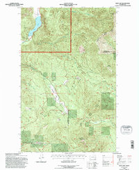
1992 Map of Deep Lake
USGS Topo · Published 1996About this map
The Colville National Forest landscape shown here, revised from 1991 aerial photography, reveals the rugged mining and logging character of the borderlands between Stevens and Pend Oreille counties. Concentrated activity around the northwest corner highlights the Thompson Wolf Mine and Capitol Mine perched above the clear waters of Deep Lake. These mining claims, along with the Tyler Mine and Maki Mine, represent the region's long-standing reliance on resource extraction within the steep terrain of the Selkirk Mountains.
Find a feature on this map
25 named features on this map. Tap any name to fly to it.
Don’t see what you’re looking for? This feature index may not catch every label — zoom into the map to look around manually.
Map Details
Editions of this 1992 Deep Lake Map
This is the sole edition of this map. No revisions or reprints were ever made.
Other maps of this area

1929 · Colville
USGS Topo · 1:125,000

1933 · Colville
USGS Topo · 1:125,000

1934 · Metaline
USGS Topo · 1:125,000

1942 · Metaline
USGS Topo · 1:125,000

1952 · Spirit
USGS Topo · 1:24,000

1952 · Deep Lake
USGS Topo · 1:24,000

1952 · Leadpoint
USGS Topo · 1:24,000

1952 · Boundary
USGS Topo · 1:24,000

1952 · Aladdin
USGS Topo · 1:24,000

1958 · Sandpoint
USGS Topo · 1:250,000