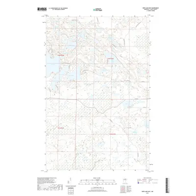
2019 Map of Deer Lake East
USGS Topo · Published 2019About this map
Glacial lakes and intricate wetlands dominate this 2019 survey of Itasca County, Minnesota. The landscape is defined by its hydrography, ranging from larger bodies like Deer Lake and Battle Lake to smaller, distinct pools such as Pughole Lake and Potato Lake. This map reveals a complex network of seasonal forest trails and county roads that navigate the waterlogged terrain, including Horseshoe Forest Trl and Roller Coaster Rd. The pattern of development here is dictated by the shoreline, with roads like N Pickerel Rd and S Pickerel Rd tracing the perimeter of Pickerel Lake. To the east, the terrain opens into broader wetland complexes around Mirror Lake and Thistledew Lake, illustrating the post-glacial topography characteristic of the Minnesota Northwoods.
Find a feature on this map
50 named features on this map. Tap any name to fly to it.
Don’t see what you’re looking for? This feature index may not catch every label — zoom into the map to look around manually.
Map Details
Editions of this 2019 Deer Lake East Map
This is the sole edition of this map. No revisions or reprints were ever made.
Other maps of this area

1919 · Release
USGS Topo · 1:62,500

1943 · Release
USGS Topo · 1:62,500

1954 · Hibbing
USGS Topo · 1:250,000

1957 · Hibbing
USGS Topo · 1:250,000

1958 · Hibbing
USGS Topo · 1:250,000

1964 · Hibbing
USGS Topo · 1:250,000

1964 · Sherry Lake
USGS Topo · 1:24,000

1970 · Rauch
USGS Topo · 1:24,000

1970 · Deer Lake East
USGS Topo · 1:24,000
1970 · Anderson Lake
USGS Topo · 1:24,000