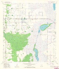
1953 Map of Deer Park SE
USGS Topo · Published 1968About this map
The St Johns River flows through an expansive wetland system in the early 1950s, defining the boundary and character of this portion of Florida. Extensive hydrologic features like St Johns Marsh and Jane Green Swamp dominate the landscape, punctuated by notable water bodies such as Lake Hellen Blazes, Sawgrass Lake, and Little Sawgrass Lake. The presence of numerous Spoil Banks and a Levee indicate early water management and drainage efforts undertaken by the U.S. Corps of Engineers. Historical landmarks including North Indian Field, Middle Indian Field, and South Indian Field are marked along the marsh edges, offering significant points of interest for local historians. Linear traces of former industry are visible through the Old Railroad Grade, which cuts across the marshy terrain between Jane Green Creek and the river.
Find a feature on this map
18 named features on this map. Tap any name to fly to it.
Don’t see what you’re looking for? This feature index may not catch every label — zoom into the map to look around manually.
Map Details
Editions of this 1953 Deer Park SE Map
5 editions found
Other maps of this area

1949 · Melbourne West
USGS Topo · 1:24,000

1949 · Eau Gallie
USGS Topo · 1:24,000

1951 · Eau Gallie
USGS Topo · 1:24,000

1951 · Melbourne West
USGS Topo · 1:24,000

1953 · Deer Park NE
USGS Topo · 1:24,000

1953 · Fellsmere NW
USGS Topo · 1:24,000

1953 · Deer Park SE
USGS Topo · 1:24,000

1953 · Kenansville
USGS Topo · 1:24,000

1953 · Deer Park NW
USGS Topo · 1:24,000

1953 · Kenansville NE
USGS Topo · 1:24,000