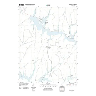
2010 Map of Deersville
USGS Topo · Published 2010About this map
Deersville serves as the central hub of this Harrison County landscape, where rural town life meets the expansive shorelines of 21st-century reservoirs. The village is well-documented for genealogical interest, featuring the Deersville Methodist Episcopal Cemetery and the Deersville Post Office. North of the town, the waters of Tappan Lake dominate the terrain, surrounded by seasonal and residential developments like the West Shore Cottage Area and East Shore Cottage Area. These man-made lakes, including Clendening Lake to the south, have reshaped the local geography, turning former stream valleys into recreational areas such as the Tappan Lake Marina and YMCA Camp. Historical markers of earlier settlement patterns remain visible through scattered sites like the Hattonia Post Office and the small community of Minksville, while the network of township roads—including the Moravian Trl—traces the older paths through the hills between Little Stillwater Creek and Brushy Fork.
Find a feature on this map
78 named features on this map. Tap any name to fly to it.
Don’t see what you’re looking for? This feature index may not catch every label — zoom into the map to look around manually.
Map Details
Editions of this 2010 Deersville Map
This is the sole edition of this map. No revisions or reprints were ever made.
Other maps of this area

1902 · Scio
USGS Topo · 1:62,500

1903 · Flushing
USGS Topo · 1:62,500

1904 · Scio
USGS Topo · 1:62,500

1905 · Flushing
USGS Topo · 1:62,500

1909 · Antrim
USGS Topo · 1:48,000

1909 · Uhrichsville
USGS Topo · 1:62,500

1911 · Antrim
USGS Topo · 1:62,500

1911 · Uhrichsville
USGS Topo · 1:62,500

1951 · Canton
USGS Topo · 1:250,000

1953 · Canton
USGS Topo · 1:250,000