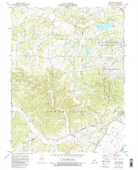
1972 Map of Defiance
USGS Topo · Published 1983About this map
The Daniel Boone Home and the adjacent rolling hills of the Femme Osage valley anchor this 1970s landscape in St. Charles County. The transition from industrial wartime usage to public research and conservation is evident in the sprawling August A Busch Memorial Wildlife Area and the University of Missouri Weldon Spring Experimental Farms, which sit alongside the Weldon Spring Ordnance Works (Abandoned). Near the Missouri River, the small settlement of Defiance sits perched above the Darst Bottoms, where the Missouri - Kansas - Texas railroad follows the riverbank. Local genealogy is supported by the locations of the Journey Cemetery, Dardenne Cemetery, and New Melle Church, while the presence of Bluff Spring School and several scattered quarries reflect the rural infrastructure of the era.
Find a feature on this map
37 named features on this map. Tap any name to fly to it.
Don’t see what you’re looking for? This feature index may not catch every label — zoom into the map to look around manually.
Map Details
Editions of this 1972 Defiance Map
3 editions found
Other maps of this area

1903 · O'Fallon
USGS Topo · 1:125,000

1931 · Brussels
USGS Topo · 1:62,500

1937 · Weldon Spring
USGS Topo · 1:24,000

1939 · Brussels
USGS Topo · 1:62,500

1940 · Eureka
USGS Topo · 1:24,000

1940 · Weldon Spring
USGS Topo · 1:24,000

1941 · Troy
USGS Topo · 1:62,500

1943 · Brussels
USGS Topo · 1:62,500

1944 · Eureka
USGS Topo · 1:24,000

1945 · Troy
USGS Topo · 1:62,500