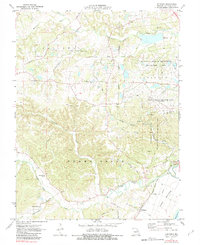
1972 Map of Defiance
USGS Topo · Published 1983About this map
The Daniel Boone Home stands as a central landmark in this landscape, situated near the winding Femme Osage Creek. This 1972 field-checked survey reveals a region defined by agricultural heritage and mid-century land use transitions, including the sprawling Weldon Spring Ordnance Works (Abandoned) and the August A Busch Memorial Wildlife Area. The settlement of Defiance sits near the Missouri-Kansas-Texas railroad line, while smaller communities like Schluersburg and local institutions such as New Melle Ch and Bluff Spring Sch provide focal points for genealogical research. The presence of the University of Missouri Weldon Spring Experimental Farms suggests an era of institutional land management. Deep valleys and creeks like Dardenne Creek carve through the terrain, leading toward the flat agricultural expanse of the Darst Bottoms in the southeast.
Find a feature on this map
40 named features on this map. Tap any name to fly to it.
Don’t see what you’re looking for? This feature index may not catch every label — zoom into the map to look around manually.
Map Details
Editions of this 1972 Defiance Map
3 editions found
Other maps of this area

1903 · O'Fallon
USGS Topo · 1:125,000

1931 · Brussels
USGS Topo · 1:62,500

1937 · Weldon Spring
USGS Topo · 1:24,000

1939 · Brussels
USGS Topo · 1:62,500

1940 · Eureka
USGS Topo · 1:24,000

1940 · Weldon Spring
USGS Topo · 1:24,000

1941 · Troy
USGS Topo · 1:62,500

1943 · Brussels
USGS Topo · 1:62,500

1944 · Eureka
USGS Topo · 1:24,000

1945 · Troy
USGS Topo · 1:62,500