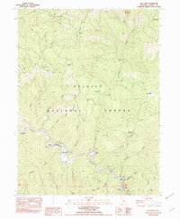
1982 Map of Del Loma
USGS Topo · Published 1982About this map
The Trinity River snakes through the heart of the Trinity National Forest, shaping a landscape of deep canyons and seasonal river bars. This early 1980s survey documents the isolated riverfront community of Del Loma, where a Trailer Park and the Hayden Flat Campground served travelers along the canyon road. The map records several family-named agricultural holdings and camps situated on rare flat ground above the water, including Brooks Ranch, Upper Waldorf Ranch, and Lower Waldorf Ranch.
Find a feature on this map
40 named features on this map. Tap any name to fly to it.
Don’t see what you’re looking for? This feature index may not catch every label — zoom into the map to look around manually.
Map Details
Editions of this 1982 Del Loma Map
2 editions found
Other maps of this area

1909 · Big Bar
USGS Topo · 1:96,000

1915 · Big Bar and Vicinity
USGS Topo · 1:250,000

1951 · Hayfork
USGS Topo · 1:62,500

1951 · Helena
USGS Topo · 1:62,500

1951 · Hyampom
USGS Topo · 1:62,500

1951 · Ironside Mountain
USGS Topo · 1:62,500

1958 · Redding
USGS Topo · 1:250,000
1982 · Jim Jam Ridge
USGS Topo · 1:24,000
1982 · Denny
USGS Topo · 1:24,000

1982 · Helena
USGS Topo · 1:24,000