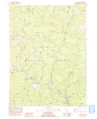
1982 Map of Del Loma
USGS Topo · Published 1985About this map
Trinity River canyons define the landscape of this 1982 survey, where the water cuts deep through the Trinity National Forest. The small settlement at Del Loma serves as a central point for river access, flanked by a series of riverside bars including Schneiders Bar, Canadian Bar, and French Bar. These flat gravel areas along the river's bends reflect a long history of seasonal activity and resource extraction, while local landmarks like Del Loma Cave and Tonys Point provide specific geographic markers for those navigating the corridor. Isolated ranching and camping outposts such as Brooks Ranch, Upper Waldorf Ranch, and Buckhorn Camp are reached by steep trails and jeep roads that climb away from the river toward Barnum Ridge. The network of creeks, including French Creek and Pelletreau Creek, illustrates the complex drainage system feeding the main river channel in this remote Trinity County interior.
Find a feature on this map
40 named features on this map. Tap any name to fly to it.
Don’t see what you’re looking for? This feature index may not catch every label — zoom into the map to look around manually.
Map Details
Editions of this 1982 Del Loma Map
2 editions found
Other maps of this area

1909 · Big Bar
USGS Topo · 1:96,000

1915 · Big Bar and Vicinity
USGS Topo · 1:250,000

1951 · Hayfork
USGS Topo · 1:62,500

1951 · Helena
USGS Topo · 1:62,500

1951 · Hyampom
USGS Topo · 1:62,500

1951 · Ironside Mountain
USGS Topo · 1:62,500

1958 · Redding
USGS Topo · 1:250,000
1982 · Jim Jam Ridge
USGS Topo · 1:24,000
1982 · Denny
USGS Topo · 1:24,000

1982 · Helena
USGS Topo · 1:24,000