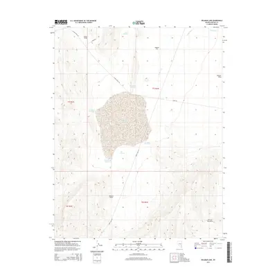
2014 Map of Delamar Lake
USGS Topo · Published 2014About this map
Delamar Lake dominates this arid landscape in the high desert of Lincoln County, situated in the heart of Delamar Valley. This dry lake bed is surrounded by a complex network of water management features, including the Delamar Flat Reservoir, New Reservoir, and several named clusters like the Southside Reservoirs and Southeast Reservoirs. The presence of Cyanide Rd in the north near the Pahroc Range hints at the region's historical mining activities, while Turtle Walk Rd snakes through the valley floor toward the Delamar Mountains. Drainage patterns are defined by seasonal features like Jumbo Wash, which cuts across Delamar Flat. This survey provides a precise look at the geography between these two mountain ranges, highlighting how water resources were identified and named in a remote basin environment.
Find a feature on this map
20 named features on this map. Tap any name to fly to it.
Don’t see what you’re looking for? This feature index may not catch every label — zoom into the map to look around manually.
Map Details
Editions of this 2014 Delamar Lake Map
This is the sole edition of this map. No revisions or reprints were ever made.
Other maps of this area

1885 · Pioche
USGS Topo · 1:250,000

1886 · Pioche
USGS Topo · 1:250,000

1945 · Alamo
USGS Topo · 1:125,000

1954 · Caliente
USGS Topo · 1:250,000

1959 · Caliente
USGS Topo · 1:250,000

1969 · Alamo SE
USGS Topo · 1:24,000

1969 · Delamar
USGS Topo · 1:24,000

1969 · Gregerson Basin
USGS Topo · 1:24,000

1969 · Delamar 3 NE
USGS Topo · 1:24,000

1969 · Lower Pahranagat Lake
USGS Topo · 1:24,000