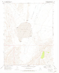
1969 Map of Delamar Lake
USGS Topo · Published 1973About this map
Petroglyphs north of the dry lake bed indicate a long history of human presence in this arid basin during the late 1960s. The landscape is dominated by the broad, flat expanse of Delamar Lake, which at this time featured a designated Landing Strip stretching across its level surface. This intersection of ancient rock art and mid-century aviation infrastructure highlights the unique utility of the Nevada desert floor.
Find a feature on this map
12 named features on this map. Tap any name to fly to it.
Don’t see what you’re looking for? This feature index may not catch every label — zoom into the map to look around manually.
Map Details
Editions of this 1969 Delamar Lake Map
This is the sole edition of this map. No revisions or reprints were ever made.
Other maps of this area

1885 · Pioche
USGS Topo · 1:250,000

1886 · Pioche
USGS Topo · 1:250,000

1945 · Alamo
USGS Topo · 1:125,000

1954 · Caliente
USGS Topo · 1:250,000

1959 · Caliente
USGS Topo · 1:250,000

1969 · Alamo SE
USGS Topo · 1:24,000

1969 · Delamar
USGS Topo · 1:24,000

1969 · Gregerson Basin
USGS Topo · 1:24,000

1969 · Delamar 3 NE
USGS Topo · 1:24,000

1969 · Lower Pahranagat Lake
USGS Topo · 1:24,000