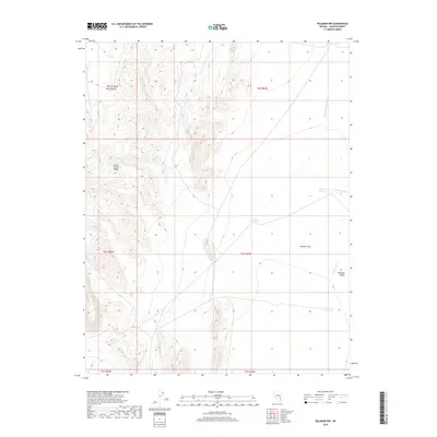
2018 Map of Delamar NW
USGS Topo · Published 2018About this map
The South Pahroc Range and the Pahroc Range dominate this desert landscape in Lincoln County, where dramatic elevation changes define the terrain. These mountain ranges overlook the broad expanse of Delamar Flat and the larger Delamar Valley, illustrating the classic basin-and-range topography of the Great Basin. This 2018 survey documents a region where water management is critical, evidenced by several small, named catchment points such as Cyanide Reservoir, Chalk Reservoir, and Powerline Reservoir. These features, alongside ephemeral drainage systems like Monkey Wrench Wash and Delamar Wash, suggest a landscape shaped by intermittent flash flooding and the historical requirements of local mining or ranching operations. The presence of the namesake Cyanide Reservoir provides a subtle nod to the area's mineral processing history, marking a site where specific industrial techniques once required managed water storage in an otherwise arid environment.
Find a feature on this map
16 named features on this map. Tap any name to fly to it.
Don’t see what you’re looking for? This feature index may not catch every label — zoom into the map to look around manually.
Map Details
Editions of this 2018 Delamar NW Map
This is the sole edition of this map. No revisions or reprints were ever made.
Other maps of this area

1885 · Pioche
USGS Topo · 1:250,000

1886 · Pioche
USGS Topo · 1:250,000

1945 · Alamo
USGS Topo · 1:125,000

1954 · Caliente
USGS Topo · 1:250,000

1959 · Caliente
USGS Topo · 1:250,000

1969 · Alamo SE
USGS Topo · 1:24,000

1969 · Delamar
USGS Topo · 1:24,000

1969 · Gregerson Basin
USGS Topo · 1:24,000

1969 · Alamo NE
USGS Topo · 1:24,000

1969 · Delamar NW
USGS Topo · 1:24,000