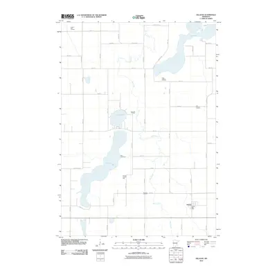
2010 Map of Delavan
USGS Topo · Published 2010About this map
Delavan serves as the primary population center in this section of Faribault County, anchored by the Delavan Post Office in the southeastern corner. The landscape is defined by its glacial hydrology, with Rice Creek winding northward to connect several prominent water bodies. The significance of these waters to the local community is evident in the cluster of burial sites nearby, including Rice Lake Cemetery and Bass Lake Cemetery. Water management is a visible priority here, noted by the presence of the Rice Lake Dam and the Vernon Finseth Dam along the southern reaches of the creek. This survey also documents the rural cemetery network vital for genealogists, featuring the Jackson Lake Cemetery in the northwest and both the West Lutheran Cemetery and East Lutheran Cemetery situated on the higher ground south of Lura Lake.
Find a feature on this map
48 named features on this map. Tap any name to fly to it.
Don’t see what you’re looking for? This feature index may not catch every label — zoom into the map to look around manually.
Map Details
Editions of this 2010 Delavan Map
This is the sole edition of this map. No revisions or reprints were ever made.
Other maps of this area

1954 · Fairmont
USGS Topo · 1:250,000

1954 · Mason City
USGS Topo · 1:250,000

1955 · Bricelyn
USGS Topo · 1:62,500

1957 · Mason City
USGS Topo · 1:250,000

1958 · Mason City
USGS Topo · 1:250,000

1958 · Fairmont
USGS Topo · 1:250,000

1967 · Winnebago
USGS Topo · 1:24,000

1967 · Huntley
USGS Topo · 1:24,000
1967 · Amboy
USGS Topo · 1:24,000
1967 · Mapleton
USGS Topo · 1:24,000