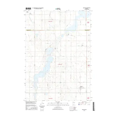
2016 Map of Delavan
USGS Topo · Published 2016About this map
Delavan serves as the primary hub for this agricultural region situated along the border of Blue Earth and Faribault counties. The landscape is defined by its glacial history, evidenced by the scattered chain of water bodies including Lura Lake, Bass Lake, and Rice Lake. The presence of the Jackson Lakebed in the northwest corner suggests a landscape in transition, where former lake areas have been reclaimed or drained for cultivation.
Find a feature on this map
63 named features on this map. Tap any name to fly to it.
Don’t see what you’re looking for? This feature index may not catch every label — zoom into the map to look around manually.
Map Details
Editions of this 2016 Delavan Map
This is the sole edition of this map. No revisions or reprints were ever made.
Other maps of this area

1954 · Fairmont
USGS Topo · 1:250,000

1954 · Mason City
USGS Topo · 1:250,000

1955 · Bricelyn
USGS Topo · 1:62,500

1957 · Mason City
USGS Topo · 1:250,000

1958 · Mason City
USGS Topo · 1:250,000

1958 · Fairmont
USGS Topo · 1:250,000

1967 · Winnebago
USGS Topo · 1:24,000

1967 · Huntley
USGS Topo · 1:24,000
1967 · Amboy
USGS Topo · 1:24,000
1967 · Mapleton
USGS Topo · 1:24,000