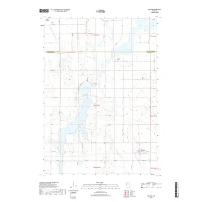
2019 Map of Delavan
USGS Topo · Published 2019About this map
Delavan serves as the primary hub in this corner of Southern Minnesota, situated at the junction of several section-line roads and the local rail corridor. The landscape is defined by its post-glacial hydrology, featuring a string of significant water bodies including Lura Lake, Bass Lake, and Rice Lake. The presence of the Jackson Lakebed and the engineered Judicial Ditch Number Forty-nine suggests a history of agricultural drainage and landscape modification common to Faribault and Blue Earth counties. For genealogists and local historians, the map provides precise locations for several rural burial grounds, such as West Lutheran Cem, East Lutheran Cem, and the Rice Lake Cem. This network of cemeteries, scattered among the township sections, reflects the early Scandinavian and German settlement patterns that established the region's farming communities.
Find a feature on this map
61 named features on this map. Tap any name to fly to it.
Don’t see what you’re looking for? This feature index may not catch every label — zoom into the map to look around manually.
Map Details
Editions of this 2019 Delavan Map
This is the sole edition of this map. No revisions or reprints were ever made.
Other maps of this area

1954 · Fairmont
USGS Topo · 1:250,000

1954 · Mason City
USGS Topo · 1:250,000

1955 · Bricelyn
USGS Topo · 1:62,500

1957 · Mason City
USGS Topo · 1:250,000

1958 · Mason City
USGS Topo · 1:250,000

1958 · Fairmont
USGS Topo · 1:250,000

1967 · Winnebago
USGS Topo · 1:24,000

1967 · Huntley
USGS Topo · 1:24,000
1967 · Amboy
USGS Topo · 1:24,000
1967 · Mapleton
USGS Topo · 1:24,000