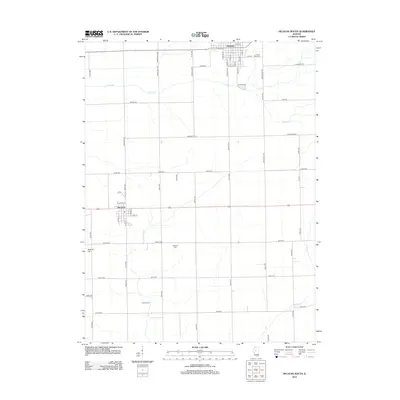
2012 Map of Delavan South
USGS Topo · Published 2012About this map
The town of Delavan anchors the northern edge of this Central Illinois landscape, where a precise grid of rural roads and drainage infrastructure supports a deep-rooted agricultural economy. Settled at a crossroads of Tazewell County, the area features family-named landmarks and essential community sites such as Prairie Rest Cem and Greenhill Cem. The terrain is shaped by water management systems like the Prairie Creek Ditch and natural courses including Crane Creek, which meander through the prairie toward the settlement of San Jose to the southwest.
Find a feature on this map
63 named features on this map. Tap any name to fly to it.
Don’t see what you’re looking for? This feature index may not catch every label — zoom into the map to look around manually.
Map Details
Editions of this 2012 Delavan South Map
This is the sole edition of this map. No revisions or reprints were ever made.
Other maps of this area

1911 · Lincoln
USGS Topo · 1:62,500

1913 · Lincoln
USGS Topo · 1:62,500

1942 · Delavan
USGS Topo · 1:62,500

1948 · Mason City
USGS Topo · 1:62,500

1949 · Mason City
USGS Topo · 1:62,500

1951 · Minier
USGS Topo · 1:62,500

1958 · Peoria
USGS Topo · 1:250,000

1961 · Peoria
USGS Topo · 1:250,000

1963 · Peoria
USGS Topo · 1:250,000
1971 · South Pekin
USGS Topo · 1:24,000