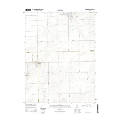
2015 Map of Delavan South
USGS Topo · Published 2015About this map
Delavan and San Jose anchor this survey of the central Illinois plains, where the boundaries of Tazewell, Mason, and Logan counties converge. The landscape is defined by its agricultural grid, with long stretches of Armington Rd and Logan Rd cutting across the terrain. Water management is evident in the channelization of Prairie Cr Ditch, while the natural winding course of Crane Cr persists to the north. For those researching local families, the map identifies several burial grounds including Prairie Rest Cem near Delavan and the more isolated Thomas Cem and Greenhill Cem further south. The topography is largely level, though it rises to a notable point at Buxton Hill in the southwest, providing one of the few breaks in the surrounding agricultural expanse.
Find a feature on this map
62 named features on this map. Tap any name to fly to it.
Don’t see what you’re looking for? This feature index may not catch every label — zoom into the map to look around manually.
Map Details
Editions of this 2015 Delavan South Map
This is the sole edition of this map. No revisions or reprints were ever made.
Other maps of this area

1911 · Lincoln
USGS Topo · 1:62,500

1913 · Lincoln
USGS Topo · 1:62,500

1942 · Delavan
USGS Topo · 1:62,500

1948 · Mason City
USGS Topo · 1:62,500

1949 · Mason City
USGS Topo · 1:62,500

1951 · Minier
USGS Topo · 1:62,500

1958 · Peoria
USGS Topo · 1:250,000

1961 · Peoria
USGS Topo · 1:250,000

1963 · Peoria
USGS Topo · 1:250,000
1971 · South Pekin
USGS Topo · 1:24,000