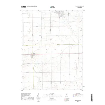
2021 Map of Delavan South
USGS Topo · Published 2021About this map
Delavan and San Jose anchor this central Illinois landscape where the borders of Tazewell, Logan, and Mason counties converge. The terrain is defined by a series of low-lying waterways including Crane Cr and Prairie Cr, which is supported by the engineered Prairie Cr Ditch. This agrarian region is mapped in fine detail, showing the grid-like road network that connects scattered homesteads and local cemeteries. Genealogists may find value in the precise locations of the Prairie Rest Cem on the outskirts of Delavan, as well as the more isolated Green Hill Cem and Thomas Cem. The map also identifies local landmarks such as Buxtom Hill and specialized thoroughfares like Morris Mill Rd and Caterpillar Rd, reflecting the transportation and agricultural history of these three adjoining counties.
Find a feature on this map
51 named features on this map. Tap any name to fly to it.
Don’t see what you’re looking for? This feature index may not catch every label — zoom into the map to look around manually.
Map Details
Editions of this 2021 Delavan South Map
This is the sole edition of this map. No revisions or reprints were ever made.
Other maps of this area

1911 · Lincoln
USGS Topo · 1:62,500

1913 · Lincoln
USGS Topo · 1:62,500

1942 · Delavan
USGS Topo · 1:62,500

1948 · Mason City
USGS Topo · 1:62,500

1949 · Mason City
USGS Topo · 1:62,500

1951 · Minier
USGS Topo · 1:62,500

1958 · Peoria
USGS Topo · 1:250,000

1961 · Peoria
USGS Topo · 1:250,000

1963 · Peoria
USGS Topo · 1:250,000
1971 · South Pekin
USGS Topo · 1:24,000