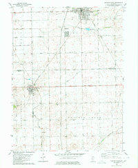
1980 Map of Delavan South
USGS Topo · Published 1980About this map
Delavan and San Jose anchor this 1980 survey, which captures the rural agricultural landscape at the tri-county intersection of Tazewell, Mason, and Logan counties. The area is defined by its extensive water management system, featuring numerous artificial drainage routes such as the Winkel Ditch, Day Ditch, and Main Ditch that feed into Crane Creek and Prairie Creek. These systems transformed the prairie into productive farmland, supported by the Illinois Central Gulf railroad that cuts diagonally across the terrain to connect the small town hubs.
Find a feature on this map
23 named features on this map. Tap any name to fly to it.
Don’t see what you’re looking for? This feature index may not catch every label — zoom into the map to look around manually.
Map Details
Editions of this 1980 Delavan South Map
This is the sole edition of this map. No revisions or reprints were ever made.
Other maps of this area

1911 · Lincoln
USGS Topo · 1:62,500

1913 · Lincoln
USGS Topo · 1:62,500

1942 · Delavan
USGS Topo · 1:62,500

1948 · Mason City
USGS Topo · 1:62,500

1949 · Mason City
USGS Topo · 1:62,500

1951 · Minier
USGS Topo · 1:62,500

1958 · Peoria
USGS Topo · 1:250,000

1961 · Peoria
USGS Topo · 1:250,000

1963 · Peoria
USGS Topo · 1:250,000
1971 · South Pekin
USGS Topo · 1:24,000