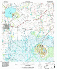
1994 Map of Delcambre
USGS Topo · Published 1998About this map
Avery Island and the famous Jungle Gardens dominate the southern marshy reaches of this Louisiana landscape, where the salt dome topography rises sharply above the surrounding wetlands. The town of Delcambre sits at the western edge, positioned along the Delcambre Canal which serves as a vital artery for the region's maritime and industrial activity. This 1994 survey reflects a complex network of drainage and transport, including the Jefferson Canal and the Norris Branch Canal, illustrating how the delta terrain has been managed for agriculture and oil extraction.
Find a feature on this map
49 named features on this map. Tap any name to fly to it.
Don’t see what you’re looking for? This feature index may not catch every label — zoom into the map to look around manually.
Map Details
Editions of this 1994 Delcambre Map
This is the sole edition of this map. No revisions or reprints were ever made.
Other maps of this area

1932 · Abbeville SE
USGS Topo · 1:31,680

1932 · Abbeville NE
USGS Topo · 1:31,680

1937 · Derouen
USGS Topo · 1:62,500

1939 · St. Martinsville
USGS Topo · 1:62,500

1945 · New Orleans
USGS Topo · 1:250,000

1946 · Milton
USGS Topo · 1:31,680

1952 · Lake Charles
USGS Topo · 1:250,000
1954 · Milton
USGS Topo · 1:31,680

1954 · Port Arthur
USGS Topo · 1:250,000
1954 · Abbeville
USGS Topo · 1:62,500