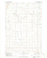
1972 Map of Dell Rapids SE
USGS Topo · Published 1973About this map
The rolling agricultural landscape of Moody and Minnehaha Counties is defined by the winding course of Pipestone Creek and its tributary, West Pipestone Creek. This 1970s survey captures a rural environment organized into townships including Logan, Alliance, and Highland, where the cultural footprint is marked by scattered religious and memorial sites. Significant local landmarks for genealogists and historians include the Reformed Church Cem and the Highland Ch Cem, which serve as anchors for the surrounding farming communities. Evidence of local industry is visible through multiple Gravel Pits located near the waterway, while a detailed network of section lines and fence markers, derived from 1969 aerial photography, illustrates the parceling of the South Dakota prairie.
Find a feature on this map
15 named features on this map. Tap any name to fly to it.
Don’t see what you’re looking for? This feature index may not catch every label — zoom into the map to look around manually.
Map Details
Editions of this 1972 Dell Rapids SE Map
2 editions found
Other maps of this area

1955 · Sioux Falls
USGS Topo · 1:250,000

1958 · Sioux Falls
USGS Topo · 1:250,000

1962 · Dell Rapids
USGS Topo · 1:24,000

1962 · Renner
USGS Topo · 1:24,000

1962 · Garretson West
USGS Topo · 1:24,000

1963 · Trent
USGS Topo · 1:24,000

1967 · Garretson East
USGS Topo · 1:24,000

1967 · Jasper
USGS Topo · 1:24,000

1967 · Jasper NW
USGS Topo · 1:24,000
1972 · Dell Rapids NE
USGS Topo · 1:24,000
Featured Places
- Blinsmon Township, SD
- Edison Township, SD
- Logan Township, SD
- Alliance Township, SD
- Palisade Township, SD