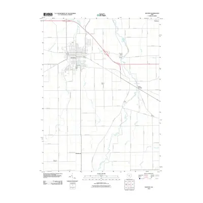
2010 Map of Delphos
USGS Topo · Published 2010About this map
Delphos serves as the central hub of this agricultural landscape, where the historical Lincoln Hwy cuts across the town grid. The surrounding countryside is defined by the winding course of the Auglaize River to the east and the straight-line drainage patterns of Jennings Creek and Flat Fork. This 2010 survey highlights the rural infrastructure of Van Wert and Allen Counties, illustrating how modern transportation like the Delphos Airport coexists with old country crossroads such as Scotts Crossing and Southworth.
Find a feature on this map
66 named features on this map. Tap any name to fly to it.
Don’t see what you’re looking for? This feature index may not catch every label — zoom into the map to look around manually.
Map Details
Editions of this 2010 Delphos Map
This is the sole edition of this map. No revisions or reprints were ever made.
Other maps of this area

1906 · Lima
USGS Topo · 1:62,500

1906 · Columbus Grove
USGS Topo · 1:62,500

1908 · Columbus Grove
USGS Topo · 1:62,500

1911 · Spencerville
USGS Topo · 1:62,500

1911 · Delphos
USGS Topo · 1:62,500

1944 · Delphos
USGS Topo · 1:62,500

1944 · Spencerville
USGS Topo · 1:62,500

1953 · Muncie
USGS Topo · 1:250,000

1956 · Muncie
USGS Topo · 1:250,000
1960 · Ottoville
USGS Topo · 1:24,000