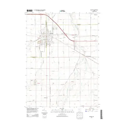
2013 Map of Delphos
USGS Topo · Published 2013About this map
Delphos sits at the intersection of three counties, where the Auglaize River and its various tributaries like Flat Fork and Pigeon Run drain the surrounding agricultural lands. This 2013 survey details the town's dense residential grid and the industrial footprint of the Delphos Water Works. The landscape outside the main settlement is defined by large farm operations, including Pohlman Farms and Rode Farms, along with a high concentration of rural burial grounds such as Hartshorn Cem and Walnut Grove Cem. Local infrastructure is marked by the Youngpeter Airport to the southwest and small outlying communities like Scotts Crossing and Southworth. The map captures a moment of modern rural development where traditional land divisions meet the expanding outskirts of town along roads like Elida Rd and Lincoln Hwy.
Find a feature on this map
112 named features on this map. Tap any name to fly to it.
Don’t see what you’re looking for? This feature index may not catch every label — zoom into the map to look around manually.
Map Details
Editions of this 2013 Delphos Map
This is the sole edition of this map. No revisions or reprints were ever made.
Other maps of this area

1906 · Lima
USGS Topo · 1:62,500

1906 · Columbus Grove
USGS Topo · 1:62,500

1908 · Columbus Grove
USGS Topo · 1:62,500

1911 · Spencerville
USGS Topo · 1:62,500

1911 · Delphos
USGS Topo · 1:62,500

1944 · Delphos
USGS Topo · 1:62,500

1944 · Spencerville
USGS Topo · 1:62,500

1953 · Muncie
USGS Topo · 1:250,000

1956 · Muncie
USGS Topo · 1:250,000
1960 · Ottoville
USGS Topo · 1:24,000