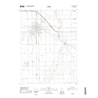
2019 Map of Delphos
USGS Topo · Published 2019About this map
Delphos serves as the primary urban center for this region, straddling the boundaries of Van Wert, Putnam, and Allen Counties. The town's grid is meticulously detailed, showing prominent streets like Lincoln Hwy and N Jefferson St. This rural landscape is heavily marked by its local history, evidenced by a dense concentration of burial grounds such as Saint Johns Cem, Hartshorn Cem, and Walnut Grove Cem. The presence of these sites, alongside Zion Church, suggests a deeply rooted community infrastructure that has persisted through generations of agricultural development.
Find a feature on this map
127 named features on this map. Tap any name to fly to it.
Don’t see what you’re looking for? This feature index may not catch every label — zoom into the map to look around manually.
Map Details
Editions of this 2019 Delphos Map
This is the sole edition of this map. No revisions or reprints were ever made.
Other maps of this area

1906 · Lima
USGS Topo · 1:62,500

1906 · Columbus Grove
USGS Topo · 1:62,500

1908 · Columbus Grove
USGS Topo · 1:62,500

1911 · Spencerville
USGS Topo · 1:62,500

1911 · Delphos
USGS Topo · 1:62,500

1944 · Delphos
USGS Topo · 1:62,500

1944 · Spencerville
USGS Topo · 1:62,500

1953 · Muncie
USGS Topo · 1:250,000

1956 · Muncie
USGS Topo · 1:250,000
1960 · Ottoville
USGS Topo · 1:24,000