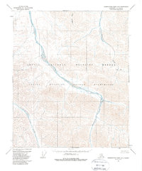
1956 Map of Demarcation Point B-3
USGS Topo · Published 1988About this map
The Egaksrak River and Ekaluakat River dominate this 1956 landscape, showcasing the complex braided drainage patterns characteristic of the North Slope. Flowing from the southern highlands, these waterways carve through a terrain that would later be designated as part of the Arctic National Wildlife Refuge and the Arctic Wildlife Refuge Wilderness. The presence of the Leffingwell Fork in the southwest highlights the importance of name-bearing landmarks in this unpopulated expanse, while Redwacke Creek feeds the northern reaches. This survey represents a period of mapping before modern infrastructure reached the area, preserving a view of the land defined entirely by its natural hydrology and the established Base Line surveying marker. The map serves as a primary record of the topography and watercourses as they existed during the initial photogrammetric surveys of the mid-1950s.
Find a feature on this map
7 named features on this map. Tap any name to fly to it.
Don’t see what you’re looking for? This feature index may not catch every label — zoom into the map to look around manually.
Map Details
Editions of this 1956 Demarcation Point B-3 Map
2 editions found
Other maps of this area

1951 · Demarcation Point
USGS Topo · 1:250,000

1955 · Demarcation Point
USGS Topo · 1:250,000

1955 · Demarcation Point C-4
USGS Topo · 1:63,360

1955 · Demarcation Point C-2
USGS Topo · 1:63,360

1955 · Demarcation Point C-3
USGS Topo · 1:63,360
1956 · Demarcation Point B-4
USGS Topo · 1:63,360
1956 · Demarcation Point B-3
USGS Topo · 1:63,360

1956 · Demarcation Point B-2
USGS Topo · 1:63,360

1964 · Demarcation Point
USGS Topo · 1:250,000

1983 · Demarcation Point A-2
USGS Topo · 1:63,360