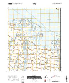
2018 Map of Demarcation Point D-2 SW
USGS Topo · Published 2018About this map
Beaufort Sea waters meet the North Slope coastline here, creating a complex system of barrier islands and tidal openings. This environment is characterized by large coastal bodies such as Beaufort Lagoon and Nuvagapak Lagoon, which are sheltered from the open sea by narrow land strips. The hydrological network is dominated by the Aichilik River and the Egaksrak River, both of which drain into the expansive Egaksrak Lagoon. These freshwater inputs through the tundra landscape meet the sea at points like Egaksrak Entrance and Siku Entrance. The map illustrates the intricate wetlands and drainage patterns typical of the Alaska North Slope Borough, including smaller tributaries like Kalokut Cr.
Find a feature on this map
14 named features on this map. Tap any name to fly to it.
Don’t see what you’re looking for? This feature index may not catch every label — zoom into the map to look around manually.
Map Details
Editions of this 2018 Demarcation Point D-2 SW Map
This is the sole edition of this map. No revisions or reprints were ever made.
Other maps of this area

1951 · Demarcation Point
USGS Topo · 1:250,000

1955 · Demarcation Point
USGS Topo · 1:250,000

1955 · Demarcation Point D-3
USGS Topo · 1:63,360

1955 · Demarcation Point D-2
USGS Topo · 1:63,360

1955 · Demarcation Point C-2
USGS Topo · 1:63,360

1955 · Demarcation Point C-3
USGS Topo · 1:63,360

1962 · Demarcation Point D-3
USGS Topo · 1:50,000

1964 · Demarcation Point
USGS Topo · 1:250,000
2018 · Demarcation Point C-2 NW
USGS Topo · 1:25,000
2018 · Demarcation Point C-2 NE
USGS Topo · 1:25,000