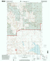
1997 Map of Demicks Lake
USGS Topo · Published 2001About this map
Little Missouri National Grassland encompasses much of this West River landscape, where the traditional ranching economy of McKenzie County is clearly mapped through family-named landmarks. Several established operations, including the M Wahus Ranch, S Grantier Ranch, and H Stole Ranch, are situated among the coulees and creek beds that define the local drainage. In the southern portion of the sheet, the waters of Demicks Lake sit at the base of Blue Butte, a prominent elevation that dominates the local horizon. The map also documents modern infrastructure and resource extraction, noting a prominent Pipeline, various Gravel Pits, and the Keene Electronic Site. These features illustrate the intersection of historical public land use and late-twentieth-century industrial development in North Dakota.
Find a feature on this map
18 named features on this map. Tap any name to fly to it.
Don’t see what you’re looking for? This feature index may not catch every label — zoom into the map to look around manually.
Map Details
Editions of this 1997 Demicks Lake Map
This is the sole edition of this map. No revisions or reprints were ever made.
Other maps of this area

1911 · Ray
USGS Topo · 1:125,000

1953 · Williston
USGS Topo · 1:250,000

1953 · Watford City
USGS Topo · 1:250,000

1957 · Williston
USGS Topo · 1:250,000

1957 · Watford City
USGS Topo · 1:250,000

1965 · Keene
USGS Topo · 1:24,000

1965 · Johnsons Corner
USGS Topo · 1:24,000

1965 · Charlson SW
USGS Topo · 1:24,000

1967 · Watford City
USGS Topo · 1:250,000

1978 · Tobacco Garden Bay
USGS Topo · 1:24,000