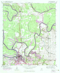
1946 Map of Demopolis
USGS Topo · Published 1984About this map
The confluence of the Tombigbee River and the Black Warrior River anchors this landscape, where the meandering waterways form distinctive loops like Twelvemile Bend and Webbs Bend. The city of Demopolis serves as a central hub for the region's transport network, situated at the junction of the Southern and ST Louis - San Francisco railroads. The map reveals a rural landscape dotted with local community institutions, including the Rosenwald Sch and the Jerusalem Ch near Arcola, as well as the Birdine Junior High Sch to the north.
Find a feature on this map
49 named features on this map. Tap any name to fly to it.
Don’t see what you’re looking for? This feature index may not catch every label — zoom into the map to look around manually.
Map Details
Editions of this 1946 Demopolis Map
3 editions found
Other maps of this area

1946 · Demopolis
USGS Topo · 1:24,000

1947 · Demopolis
USGS Topo · 1:24,000

1947 · Mason Bend
USGS Topo · 1:24,000

1947 · Forkland
USGS Topo · 1:24,000

1948 · Mason Bend
USGS Topo · 1:24,000

1948 · Mc Dowell
USGS Topo · 1:24,000

1949 · Mc Dowell
USGS Topo · 1:24,000

1949 · Forkland
USGS Topo · 1:24,000

1953 · Montgomery
USGS Topo · 1:250,000

1956 · Montgomery
USGS Topo · 1:250,000