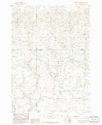
1986 Map of Dempsey Meadows
USGS Topo · Published 1986About this map
Dempsey Meadows serves as the central focal point for this 1980s landscape, where the high-altitude drainage systems of Elmore, Camas, and Gooding Counties converge. The terrain is defined by a complex network of seasonal and perennial watercourses, including the headwaters of Dempsey Creek and its tributary, East Fork Dempsey Creek. A prominent topographical landmark, The Knob, stands out in the northeastern quadrant, providing a fixed reference point above the surrounding gulches and creek beds.
Find a feature on this map
14 named features on this map. Tap any name to fly to it.
Don’t see what you’re looking for? This feature index may not catch every label — zoom into the map to look around manually.
Map Details
Editions of this 1986 Dempsey Meadows Map
This is the sole edition of this map. No revisions or reprints were ever made.
Other maps of this area

1892 · Camas Prairie
USGS Topo · 1:125,000

1893 · Camas Prairie
USGS Topo · 1:125,000

1955 · Hailey
USGS Topo · 1:250,000

1957 · Fairfield
USGS Topo · 1:62,500

1957 · Davis Mountain
USGS Topo · 1:62,500

1958 · King Hill
USGS Topo · 1:62,500

1959 · Hailey
USGS Topo · 1:250,000

1962 · Hailey
USGS Topo · 1:250,000

1963 · High Prairie
USGS Topo · 1:24,000

1963 · Hill City
USGS Topo · 1:24,000