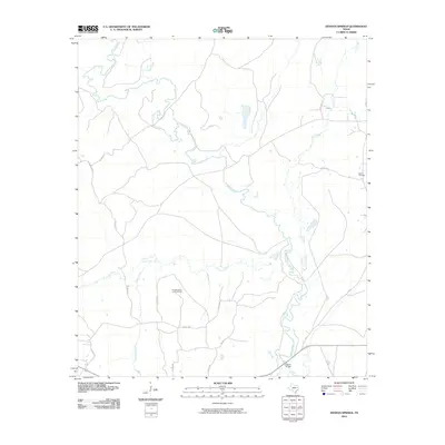
2010 Map of Denson Springs
USGS Topo · Published 2010About this map
The Neches River winds through this Anderson County landscape, carving a complex riparian corridor as it flows south toward the Fastrill Bridge. This 2010 survey illustrates a region defined by its watercourses and rural infrastructure, where major tributaries like Tailes Creek and Bull Creek feed into the primary river system. The terrain rises to a prominent point at Bird Mountain, which is punctuated by a Lookout Tower, likely serving as a high-altitude observation point for the surrounding timberlands.
Find a feature on this map
22 named features on this map. Tap any name to fly to it.
Don’t see what you’re looking for? This feature index may not catch every label — zoom into the map to look around manually.
Map Details
Editions of this 2010 Denson Springs Map
This is the sole edition of this map. No revisions or reprints were ever made.
Other maps of this area

1943 · Rusk
USGS Topo · 1:62,500

1945 · Rusk
USGS Topo · 1:62,500

1946 · Alto
USGS Topo · 1:62,500

1951 · Jacksonville
USGS Topo · 1:62,500

1952 · Slocum
USGS Topo · 1:62,500

1953 · Palestine
USGS Topo · 1:250,000

1957 · Palestine
USGS Topo · 1:250,000
1973 · Pryor Mountain
USGS Topo · 1:24,000
1973 · Weches
USGS Topo · 1:24,000
1973 · Rusk
USGS Topo · 1:24,000