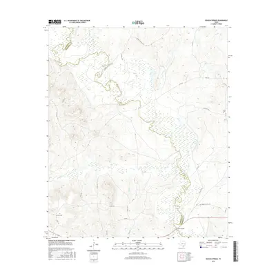
2016 Map of Denson Springs
USGS Topo · Published 2016About this map
Denson Springs sits in the wooded uplands of Anderson County, where the landscape is defined by the winding course of the Neches River. This 2016 survey highlights the river’s extensive floodplain and the numerous tributaries that drain into it, including Ioni Cr, Cedar Cr, and Bird Br. The boundary between Anderson and Cherokee counties follows the river's center, a traditional natural border in this part of East Texas. Notable landmarks like the Fastrill Bridge span the waterway, providing essential connectivity in an area otherwise characterized by rural county roads and dense forest management. Large tracts are dedicated to outdoor recreation, as seen with the Cherokee Hunting Club and Bull Creek Hunting Club, reflecting the region's long-standing reliance on timber and wildlife resources. To the east, the Sardis Cem stands as a quiet marker of local family history and settlement patterns near FM 1857.
Find a feature on this map
30 named features on this map. Tap any name to fly to it.
Don’t see what you’re looking for? This feature index may not catch every label — zoom into the map to look around manually.
Map Details
Editions of this 2016 Denson Springs Map
This is the sole edition of this map. No revisions or reprints were ever made.
Other maps of this area

1943 · Rusk
USGS Topo · 1:62,500

1945 · Rusk
USGS Topo · 1:62,500

1946 · Alto
USGS Topo · 1:62,500

1951 · Jacksonville
USGS Topo · 1:62,500

1952 · Slocum
USGS Topo · 1:62,500

1953 · Palestine
USGS Topo · 1:250,000

1957 · Palestine
USGS Topo · 1:250,000
1973 · Pryor Mountain
USGS Topo · 1:24,000
1973 · Weches
USGS Topo · 1:24,000
1973 · Rusk
USGS Topo · 1:24,000