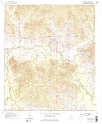
1963 Map of Dentville
USGS Topo · Published 1976About this map
Bayou Pierre carves a winding path through the center of this Mississippi landscape, defining the local topography and drainage patterns. Small rural communities like Dentville and Hoodtown are linked by a network of unimproved and light-duty roads, reflecting the era's agrarian layout. The region is particularly rich in genealogical landmarks, including a high density of rural houses of worship such as New Mt Zion Ch, Pike Bluff Ch, and Fair View Ch. Numerous family and community burial grounds, including Green Cem and Pleasant Hill Cem, are scattered across the terrain near water sources like Sand Creek and Boggy Bayou. The presence of several Gravel Pits suggests the localized extraction of natural resources as a minor industry alongside the established farming settlements of the early 1960s.
Find a feature on this map
35 named features on this map. Tap any name to fly to it.
Don’t see what you’re looking for? This feature index may not catch every label — zoom into the map to look around manually.
Map Details
Editions of this 1963 Dentville Map
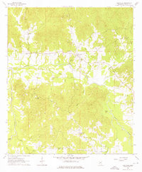
3 editions found

Other maps of this area

1903 · Jackson
USGS Topo · 1:125,000

1937 · Terry
USGS Topo · 1:48,000

1943 · Terry
USGS Topo · 1:62,500

1953 · Natchez
USGS Topo · 1:250,000

1955 · Jackson
USGS Topo · 1:250,000

1956 · Natchez
USGS Topo · 1:250,000

1959 · Natchez
USGS Topo · 1:250,000

1961 · Jackson
USGS Topo · 1:250,000

1962 · Jackson
USGS Topo · 1:250,000

1962 · Utica West
USGS Topo · 1:24,000