
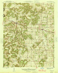
1946 Map of Depauw
USGS Topo · Published 1946About this map
Depauw and Ramsey serve as the primary rail-oriented settlements in this part of Harrison County, situated along the Southern line in the years immediately following the war. The geography is defined by the winding course of the Blue River, which forms the boundary with Crawford County in the northwest. A sharp meander in the river creates the distinctive Devils Elbow, a landmark in the rugged southwestern corner of the quadrangle.
Find a feature on this map
21 named features on this map. Tap any name to fly to it.
Don’t see what you’re looking for? This feature index may not catch every label — zoom into the map to look around manually.
Map Details
Editions of this 1946 Depauw Map
2 editions found
Other maps of this area

1931 · Corydon
USGS Topo · 1:62,500

1944 · Corydon West
USGS Topo · 1:24,000

1946 · Leavenworth
USGS Topo · 1:24,000

1947 · Leavenworth
USGS Topo · 1:24,000

1947 · Corydon West
USGS Topo · 1:24,000

1947 · Hardinsburg
USGS Topo · 1:24,000

1948 · Corydon East
USGS Topo · 1:24,000

1948 · Milltown
USGS Topo · 1:24,000

1949 · Hardinsburg
USGS Topo · 1:24,000

1950 · Palmyra
USGS Topo · 1:24,000