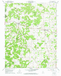
1962 Map of Depauw
USGS Topo · Published 1973About this map
Depauw and Ramsey serve as central points along the Southern railroad line as it traverses Harrison County in the early 1960s. The landscape transitions from the dense woodlands of the Harrison-Crawford State Forest in the west toward the agricultural expanse of Clover Valley to the east. This era shows a community rooted in local institutions, evidenced by the high density of rural houses of worship such as St Bernards Ch, Woods Chapel, and Pennington Chapel.
Find a feature on this map
52 named features on this map. Tap any name to fly to it.
Don’t see what you’re looking for? This feature index may not catch every label — zoom into the map to look around manually.
Map Details
Editions of this 1962 Depauw Map
3 editions found
Other maps of this area

1931 · Corydon
USGS Topo · 1:62,500

1944 · Corydon West
USGS Topo · 1:24,000

1946 · Leavenworth
USGS Topo · 1:24,000

1946 · Depauw
USGS Topo · 1:24,000

1947 · Leavenworth
USGS Topo · 1:24,000

1947 · Corydon West
USGS Topo · 1:24,000

1947 · Hardinsburg
USGS Topo · 1:24,000

1948 · Corydon East
USGS Topo · 1:24,000

1948 · Milltown
USGS Topo · 1:24,000

1949 · Hardinsburg
USGS Topo · 1:24,000