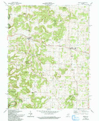
1962 Map of Depauw
USGS Topo · Published 1994About this map
Depauw serves as a central point in this rural landscape, situated along the Southern railroad line where the industrial presence of a Quarry and Tunnel meets agricultural life. The terrain is defined by a series of prominent ridges including Orchard Ridge, Byrd Ridge, and Pennington Ridge, which separate the drainage of the Blue River from the Clover Valley. These heights often bear the names of local families, such as Marion Herthel Hill and Henry Ott Hill, reflecting the deep-rooted settlement history of the area.
Find a feature on this map
48 named features on this map. Tap any name to fly to it.
Don’t see what you’re looking for? This feature index may not catch every label — zoom into the map to look around manually.
Map Details
Editions of this 1962 Depauw Map
3 editions found
Other maps of this area

1931 · Corydon
USGS Topo · 1:62,500

1944 · Corydon West
USGS Topo · 1:24,000

1946 · Leavenworth
USGS Topo · 1:24,000

1946 · Depauw
USGS Topo · 1:24,000

1947 · Leavenworth
USGS Topo · 1:24,000

1947 · Corydon West
USGS Topo · 1:24,000

1947 · Hardinsburg
USGS Topo · 1:24,000

1948 · Corydon East
USGS Topo · 1:24,000

1948 · Milltown
USGS Topo · 1:24,000

1949 · Hardinsburg
USGS Topo · 1:24,000