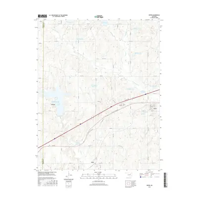
2016 Map of Depew
USGS Topo · Published 2016About this map
Stroud and Depew anchor this portion of the Oklahoma landscape, connected by the historical corridor of W Old State Highway 66. The area is defined by an extensive water management system, featuring numerous reservoirs like Little Deep Fork Cr Site 7 Reservoir and Salt Camp Creek Site Number 6 Reservoir that dot the drainages of Little Deep Fork Cr. These sites suggest a landscape heavily modified for flood control and water storage throughout the mid-to-late 20th century. Near the village of Milfay, the terrain transitions into the valleys of Salt Camp Cr. Cultural landmarks including the Oakdale Cem and Memorial Club Cem provide points of interest for genealogists tracing local families. The map also captures the recreational and utility value of the region through Stroud Lake and the Stroud Reservoir, highlighting the intersection of rural life and civil engineering.
Find a feature on this map
62 named features on this map. Tap any name to fly to it.
Don’t see what you’re looking for? This feature index may not catch every label — zoom into the map to look around manually.
Map Details
Editions of this 2016 Depew Map
This is the sole edition of this map. No revisions or reprints were ever made.
Other maps of this area

1901 · Nuyaka
USGS Topo · 1:125,000

1916 · Bristow
USGS Topo · 1:62,500

1929 · Stroud
USGS Topo · 1:62,500

1931 · Drumright
USGS Topo · 1:62,500

1932 · Stroud
USGS Topo · 1:62,500

1954 · Oklahoma City
USGS Topo · 1:250,000

1957 · Oklahoma City
USGS Topo · 1:250,000

1963 · Oklahoma City
USGS Topo · 1:250,000
1971 · Bellvue
USGS Topo · 1:24,000
1973 · Gypsy
USGS Topo · 1:24,000