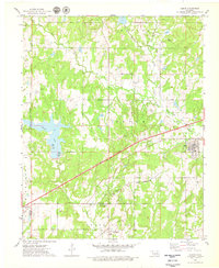
1975 Map of Depew
USGS Topo · Published 1979About this map
The town of Depew and its surrounding Creek County landscape are defined by a complex intersection of energy extraction and transport infrastructure in the mid-1970s. The Turner Toll Road cuts a sharp diagonal through the center of the sheet, bridging the gap between the older St Louis San Francisco rail corridor and the scattered oil wells that pockmark the hills. To the west, the expansive Stroud Lake dominates the terrain, featuring a boat ramp picnic area for local recreation.
Find a feature on this map
30 named features on this map. Tap any name to fly to it.
Don’t see what you’re looking for? This feature index may not catch every label — zoom into the map to look around manually.
Map Details
Editions of this 1975 Depew Map
This is the sole edition of this map. No revisions or reprints were ever made.
Other maps of this area

1901 · Nuyaka
USGS Topo · 1:125,000

1916 · Bristow
USGS Topo · 1:62,500

1929 · Stroud
USGS Topo · 1:62,500

1931 · Drumright
USGS Topo · 1:62,500

1932 · Stroud
USGS Topo · 1:62,500

1954 · Oklahoma City
USGS Topo · 1:250,000

1957 · Oklahoma City
USGS Topo · 1:250,000

1963 · Oklahoma City
USGS Topo · 1:250,000
1971 · Bellvue
USGS Topo · 1:24,000
1973 · Gypsy
USGS Topo · 1:24,000