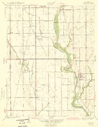
1943 Map of Derby
USGS Topo · Published 1943About this map
Arkansas River hydrology and early Sedgwick County transport networks define this early 1940s landscape south of Wichita. The area shows a transition from agricultural prairie to more concentrated settlements, with Derby and Haysville serving as primary hubs. The map is particularly notable for capturing the distinct sites of Old Waco and New Waco, reflecting the evolution of rural communities near Waco School and Waco Cem.
Find a feature on this map
30 named features on this map. Tap any name to fly to it.
Don’t see what you’re looking for? This feature index may not catch every label — zoom into the map to look around manually.
Map Details
Editions of this 1943 Derby Map
2 editions found
Other maps of this area

1889 · Wichita
USGS Topo · 1:125,000

1890 · Wellington
USGS Topo · 1:125,000

1894 · Wichita
USGS Topo · 1:125,000

1943 · Wichita West
USGS Topo · 1:31,680

1943 · Wichita East
USGS Topo · 1:31,680

1943 · Derby
USGS Topo · 1:31,680

1943 · Bayneville
USGS Topo · 1:31,680

1945 · Andover
USGS Topo · 1:31,680

1950 · Bayneville
USGS Topo · 1:24,000

1955 · Belle Plaine
USGS Topo · 1:24,000