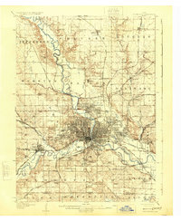
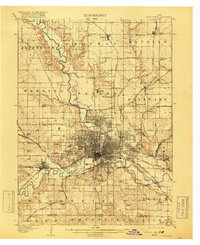
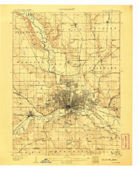
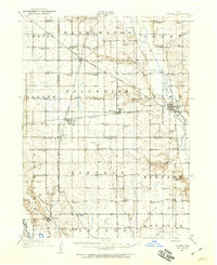
1907 Map of Des Moines
USGS Topo · Published 1924About this map
Des Moines serves as the focal point of this early twentieth-century landscape, appearing here as a dense hub of industry and transport at the confluence of the Des Moines River and the Raccoon River. The city’s core is surrounded by an extensive network of iron, with lines such as the Chicago Great Western RR, Wabash RR, and the Inter-Urban Electric RR connecting the capital to outlying settlements like Valley Junction and Saylorville. This era reveals a county defined by rural education and community spaces, where family-named landmarks like the Red Brick School and Hammer School dot the townships, and recreational areas such as the Chautauqua Grounds and State Fairgrounds suggest a growing urban culture. To the south, Fort Des Moines stands near the edge of the developing grid, while numerous small mining or rail stops like Carbondale and Oralabor highlight the region's diverse economic foundations before modern expansion.
Find a feature on this map
80 named features on this map. Tap any name to fly to it.
Don’t see what you’re looking for? This feature index may not catch every label — zoom into the map to look around manually.
Map Details
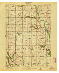
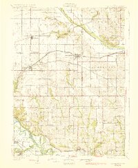
Editions of this 1907 Des Moines Map
3 editions found
Other maps of this area

1905 · Des Moines
USGS Topo · 1:62,500
1907 · Des Moines
USGS Topo · 1:62,500

1908 · Waukee
USGS Topo · 1:62,500
1910 · Milo
USGS Topo · 1:62,500

1911 · Madrid
USGS Topo · 1:62,500
1911 · Slater
USGS Topo · 1:62,500
1913 · Slater
USGS Topo · 1:62,500

1914 · Madrid
USGS Topo · 1:62,500
1930 · Mitchellville
USGS Topo · 1:62,500

1931 · Indianola
USGS Topo · 1:62,500