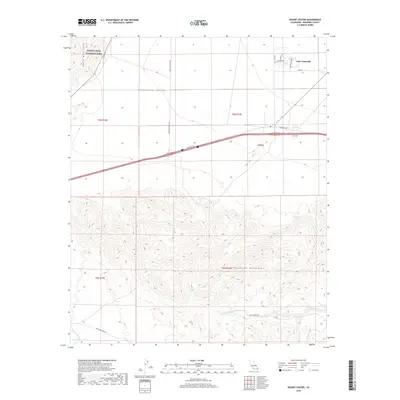
2018 Map of Desert Center
USGS Topo · Published 2018About this map
Lake Tamarisk serves as a distinct residential oasis within the arid Chuckwalla Valley, established as a planned community surrounding its namesake water body. This 2018 survey illustrates the sharp contrast between the organized street grid of Lake Tamarisk Dr and Shasta Dr against the surrounding desert wilderness. To the west, the rugged elevations of the Eagle Mountains mark the boundary of Joshua Tree National Park, while the southern reaches of the map are defined by the jagged topography of the Chuckwalla Mountains. The landscape is carved by a network of seasonal drainages, including Corn Springs Wash, Irish Wash, and Red Cloud Wash, which dictate the natural movement of water through the valley. This map captures a modern snapshot of a remote desert outpost where infrastructure like Ragsdale Rd and Eagle Mountain Rd provide essential access to the Colorado Desert interior.
Find a feature on this map
26 named features on this map. Tap any name to fly to it.
Don’t see what you’re looking for? This feature index may not catch every label — zoom into the map to look around manually.
Map Details
Editions of this 2018 Desert Center Map
This is the sole edition of this map. No revisions or reprints were ever made.
Other maps of this area

1940 · Canyon Spring
USGS Topo · 1:62,500

1943 · Canyon Spring
USGS Topo · 1:62,500

1943 · Coxcomb Mountains
USGS Topo · 1:62,500

1944 · Eagle Tank
USGS Topo · 1:62,500

1944 · Chuckwalla Mountains
USGS Topo · 1:62,500

1944 · Coxcomb Mountains
USGS Topo · 1:62,500

1954 · Salton Sea
USGS Topo · 1:250,000

1955 · Salton Sea
USGS Topo · 1:250,000

1959 · Salton Sea
USGS Topo · 1:250,000

1963 · Salton Sea
USGS Topo · 1:250,000