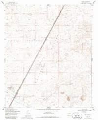
1955 Map of Desert
USGS Topo · Published 1985About this map
Fort Bliss Military Reservation dominates the arid expanse of the Tularosa Valley in this mid-century survey. The landscape is defined by its military use and sparse infrastructure, centered around the Southern Pacific railroad line and a Telephone route that bisect the desert terrain. Small outposts and water sources, such as Desert and Alvarado, provide rare points of human activity in an otherwise open environment. To the southeast, the prominent Three Buttes rise as a significant landmark. The presence of Alvarado Water and Alvarado Tank No 1 highlights the critical role of water management for both the military and the railroad in this high-desert region of New Mexico. The map illustrates a period of strategic military land use during the height of the Cold War era.
Find a feature on this map
14 named features on this map. Tap any name to fly to it.
Don’t see what you’re looking for? This feature index may not catch every label — zoom into the map to look around manually.
Map Details
Editions of this 1955 Desert Map
2 editions found
Other maps of this area

1940 · Orogrande
USGS Topo · 1:62,500

1940 · Newman
USGS Topo · 1:62,500

1941 · Desert
USGS Topo · 1:62,500

1943 · Parker Lake
USGS Topo · 1:62,500

1943 · Desert
USGS Topo · 1:62,500

1943 · Newman
USGS Topo · 1:62,500

1943 · Orogrande
USGS Topo · 1:62,500

1947 · Desert NE
USGS Topo · 1:24,000

1948 · El Wood
USGS Topo · 1:24,000
1948 · Desert
USGS Topo · 1:24,000