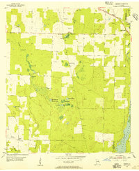
1954 Map of Desser
USGS Topo · Published 1955About this map
Lela, Brinson, and Desser anchor this survey of the Georgia borderlands, where the landscape is defined by a dense network of swampy depressions and limestone sinks. This 1954 environment is punctuated by features like Goose Lake, Rock Pond, and Wash Pond, alongside smaller wetlands such as Sykes Water Gap and Buttonwood Pond. The social geography of the era is remarkably well-preserved through family-named sites and community centers, including the Rock Pond Courthouse and Rock Pond Sch. These landmarks, along with Jeffrey Chapel and multiple family burial grounds like Ash Cem and Chason Cem, reflect a deeply rooted rural society. The northeastern corner shows the Atlantic Coast Line railroad and the waters of Spring Creek, while the southern reaches reveal the expanding margins of Lake Decatur along the Seminole and Decatur county line.
Find a feature on this map
31 named features on this map. Tap any name to fly to it.
Don’t see what you’re looking for? This feature index may not catch every label — zoom into the map to look around manually.
Map Details
Editions of this 1954 Desser Map
3 editions found
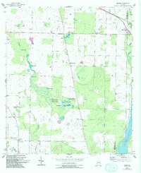
Other maps of this area

1953 · Dothan
USGS Topo · 1:250,000

1954 · Dothan
USGS Topo · 1:250,000

1954 · Steam Mill
USGS Topo · 1:24,000

1954 · Desser
USGS Topo · 1:24,000

1954 · Tallahassee
USGS Topo · 1:250,000

1955 · Dothan
USGS Topo · 1:250,000

1955 · Fairchild
USGS Topo · 1:24,000

1955 · Reynoldsville
USGS Topo · 1:24,000

1955 · Bainbridge
USGS Topo · 1:62,500

1959 · Tallahassee
USGS Topo · 1:250,000