1970 Map of Destin
USGS Topo · Published 1977About this map
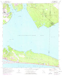
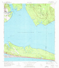
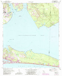
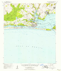
Moreno Point and the evolving coastline of the Florida Panhandle define this 1970s landscape, captured shortly before the region's massive residential expansion. The map detail shows Destin as a developing coastal community, where the Destin Sch and local trailer parks sit tucked behind the Sand Dunes of the Gulf of Mexico. Northward, the waters of Choctawhatchee Bay separate the southern peninsula from the expansive grounds of Eglin Air Force Base, where a warning for Danger Unexploded Bombs marks the specialized military use of the shoreline near Rocky Bayou.
Find a feature on this map
35 named features on this map. Tap any name to fly to it.
Don’t see what you’re looking for? This feature index may not catch every label — zoom into the map to look around manually.
Map Details
Editions of this 1970 Destin Map
3 editions found
Other maps of this area

1934 · Holt
USGS Topo · 1:48,000

1934 · Niceville
USGS Topo · 1:48,000

1935 · Villa Tasso
USGS Topo · 1:48,000

1936 · Niceville
USGS Topo · 1:62,500

1937 · Holt
USGS Topo · 1:62,500

1938 · Mary Esther
USGS Topo · 1:62,500

1938 · Villa Tasso
USGS Topo · 1:62,500
1956 · Niceville
USGS Topo · 1:62,500
1956 · Fort Walton Beach
USGS Topo · 1:62,500
1956 · Holt
USGS Topo · 1:62,500