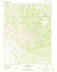
1966 Map of Devils Hole Gulch
USGS Topo · Published 1977About this map
The Wilson Creek Oil Field dominates this section of the Danforth Hills in Northwestern Colorado, showcasing the industrial footprint of petroleum extraction in the mid-1960s. Located along the border of Moffat and Rio Blanco Counties, the landscape is a network of access roads, numerous Oil Wells, and specialized infrastructure like a Pumping Station, Water Tank, and Radio Facility. The presence of Wilson Creek Camp suggests a concentrated operational center for workers in this remote terrain. Beyond the industrial sites, the topography is defined by high points like Old Baldy and Devils Hole Mountain, while drainage is handled by a complex system of gulches, including Devils Hole Gulch and Strawberry Creek. This survey captures the region just as photogrammetric mapping was being refined, documenting the specific locations of many drill holes and wells scattered across Tepee Park and Coal Butte.
Find a feature on this map
32 named features on this map. Tap any name to fly to it.
Don’t see what you’re looking for? This feature index may not catch every label — zoom into the map to look around manually.
Map Details
Editions of this 1966 Devils Hole Gulch Map
3 editions found
Other maps of this area

1907 · White River
USGS Topo · 1:125,000

1910 · Danforth Hills
USGS Topo · 1:125,000

1910 · White River
USGS Topo · 1:125,000

1912 · Meeker
USGS Topo · 1:62,500

1912 · Axial
USGS Topo · 1:62,500

1914 · Meeker
USGS Topo · 1:62,500

1914 · Axial
USGS Topo · 1:62,500

1954 · Vernal
USGS Topo · 1:250,000

1954 · Craig
USGS Topo · 1:250,000

1957 · Craig
USGS Topo · 1:250,000