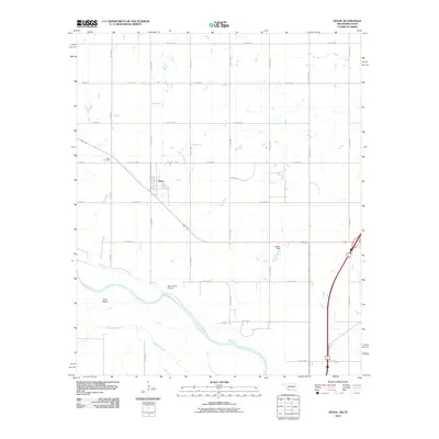
2010 Map of Devol
USGS Topo · Published 2010About this map
Devol stands as the primary settlement on this Cotton County landscape, positioned just north of the winding course of the Red River. The township's layout is defined by a rigorous grid of section-line roads, such as Co RD e1940 and Co RD n2460, which connect local landmarks including the Devol Cemetery and Locust St. Along the northern banks of the river, North Bank Siding reflects the historical importance of the rail corridor passing through the region. The map captures a transition in the hydrologic landscape where Wildhorse Creek and Bule Creek converge toward the main river channel. South of the main settlement, Goat Island sits within the shifting braided channels of the river, while the Tulssis Dam provides evidence of local water management in this agricultural borderland between Oklahoma and Texas.
Find a feature on this map
27 named features on this map. Tap any name to fly to it.
Don’t see what you’re looking for? This feature index may not catch every label — zoom into the map to look around manually.
Map Details
Editions of this 2010 Devol Map
This is the sole edition of this map. No revisions or reprints were ever made.
Other maps of this area

1915 · Clara
USGS Topo · 1:24,000

1915 · Burkburnett
USGS Topo · 1:24,000

1918 · Buckburnett
USGS Topo · 1:31,680

1918 · Clara
USGS Topo · 1:31,680

1955 · Lawton
USGS Topo · 1:250,000

1957 · Burkburnett
USGS Topo · 1:62,500

1957 · Randlett
USGS Topo · 1:62,500

1962 · Chattanooga
USGS Topo · 1:62,500

1962 · Walters
USGS Topo · 1:62,500
1972 · Clara
USGS Topo · 1:24,000