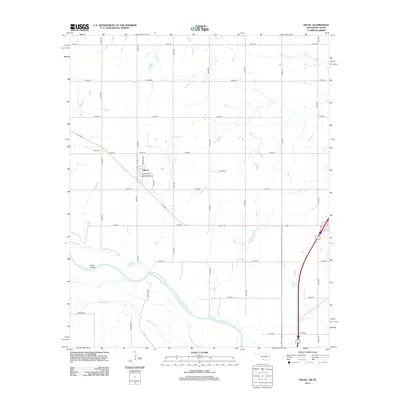
2012 Map of Devol
USGS Topo · Published 2012About this map
Devol sits at the heart of this landscape, organized around a traditional grid featuring streets like Wichita Ave, Enid Ave, and Mulberry St. To the northwest, the Devol Cem serves as a significant landmark for local family historians. The southern portion of the territory is defined by the winding course of the Red River, which forms the border between Oklahoma and Texas. Near this riparian boundary, Goat Island sits within the river's path, flanked by the outlets of Wildhorse Cr and Bule Cr. The road network is primarily composed of a regular section-line grid, punctuated by regional routes such as Co Hwy, reflecting the agricultural and rural character of Cotton County during this era of digital mapping.
Find a feature on this map
32 named features on this map. Tap any name to fly to it.
Don’t see what you’re looking for? This feature index may not catch every label — zoom into the map to look around manually.
Map Details
Editions of this 2012 Devol Map
This is the sole edition of this map. No revisions or reprints were ever made.
Other maps of this area

1915 · Clara
USGS Topo · 1:24,000

1915 · Burkburnett
USGS Topo · 1:24,000

1918 · Buckburnett
USGS Topo · 1:31,680

1918 · Clara
USGS Topo · 1:31,680

1955 · Lawton
USGS Topo · 1:250,000

1957 · Burkburnett
USGS Topo · 1:62,500

1957 · Randlett
USGS Topo · 1:62,500

1962 · Chattanooga
USGS Topo · 1:62,500

1962 · Walters
USGS Topo · 1:62,500
1972 · Clara
USGS Topo · 1:24,000